Drought

The last two weeks of Tuesday Nature Walks have been great fun.
Sign up here for May nature walks, every Tuesday from 9:30-10:30 am.
If these days and times don't work for you contact me here and we'll see if we can make other arrangements.
You may have noticed the water level of the ponds at Nixon Park is down. Are we in a dry spell? A drought? How do we know?
The story of humanity is the story of water; so we all ought to know where our water comes from and where our wastewater goes. (Those are two questions on Peter Warshall's Big Here Quiz). We should also know our present drought status, what water levels are measured, how often and who measures them.
Our creek, the Eastern Branch of the Red Clay Creek is generally low and quiet. Storms swell the creek: rain in, water rises and drains down fast - the weather directly translated.
Chester County is currently under a Drought Warning, the middle tier of Pennsylvania’s three-stage system — Watch, Warning, Emergency. Water levels are down far enough that the state is asking for voluntary reductions in water use, but mandatory restrictions follow a full Emergency declaration.
Drought status is determined by measurements over three to twelve months of observations, it's often counter-intuitive. Remember all that snow we had this past winter, didn't make much of a dent in the drought.
Five indicators: streamflow, precipitation, reservoir levels, groundwater depth, and soil moisture are tracked by Pennsylvania’s Commonwealth Drought Task Force and the Department of Environmental Protection.
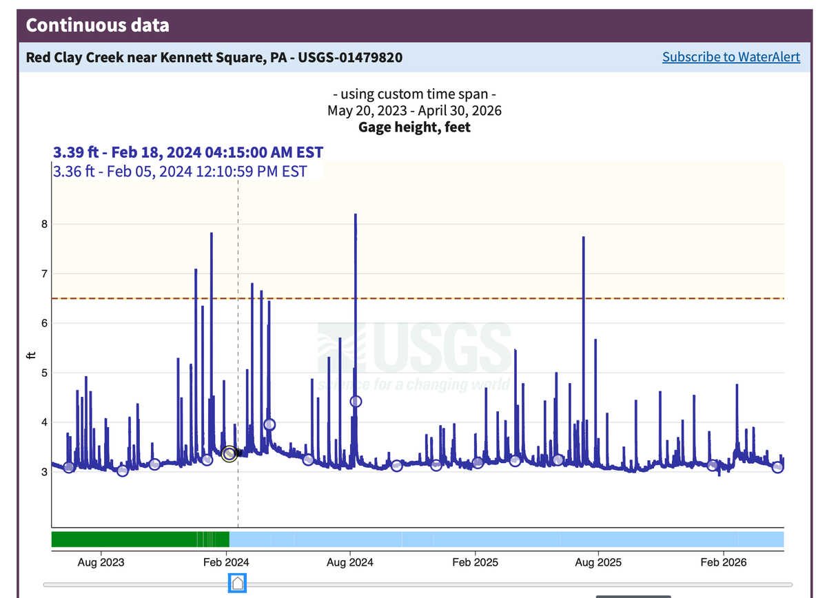
In Chester County the United States Geological Service (USGS) monitors observation wells. One local well (CH-10) in West Marlborough records readings every 15 minutes. The USGS maintains streamflow gages on the Brandywine, Red Clay, and White Clay Creeks. The Chester County Water Resources Authority (CCWRA) coordinates a volunteer observer network for precipitation data.
The County's water levels page is a good place to start if you'd like to do more of a deep dive into the specifics.
While spring rains have helped surface conditions local groundwater is still low. The rain will eventually soak into the soil, move through rock. and slowly recharge wells that may have been drawing down for months.
The 2024 drought was the driest Chester County had seen since the 2002 emergency declaration. We returned to normal in July of last year, but not for long. By fall, the deficit was building again.